There’s something truly magical about seeing a familiar place from an entirely new perspective. For residents and visitors alike, capturing Gisborne’s natural beauty with drone photography offers an unparalleled view of this stunning Victorian gem. Nestled within the picturesque Macedon Ranges, Gisborne is a tapestry of rolling hills, lush vineyards, and charming rural landscapes that truly come alive when viewed from the sky.
Why Drone Photography Elevates Gisborne’s Charm
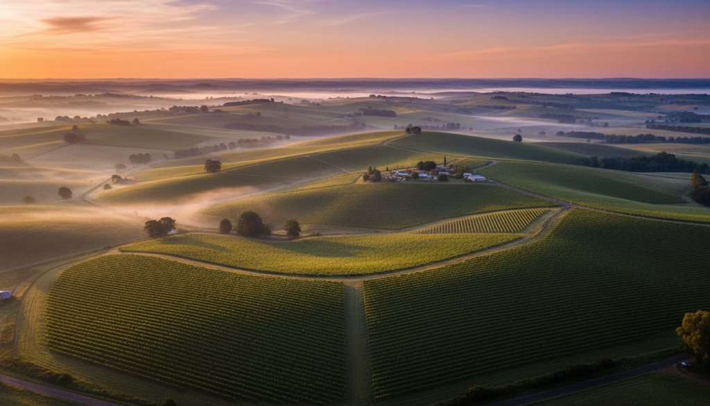
Traditional photography captures the essence of a moment, but drone photography adds a layer of grandeur and scope that’s simply impossible to achieve from the ground. Imagine sweeping vistas of the Gisborne Racecourse, the intricate patterns of agricultural land, or the serene beauty of the local waterways winding through the countryside. Drones allow us to ascend above the mundane, revealing the vastness and intricate details of the landscape that often go unnoticed.
From the vibrant autumn colours blanketing the trees near Mount Gisborne to the golden glow of summer sunsets over the local wineries, every season paints a unique picture. Drone photography excels at capturing these large-scale transformations, making it ideal for everything from landscape photography portfolios to documenting events or showcasing real estate properties with a breathtaking overview.
Unveiling Gisborne’s Hidden Gems from Above
Gisborne is renowned for its tranquil environment and close-knit community feel. While driving through its leafy streets or exploring its charming boutiques, you get a sense of its character. However, from an aerial viewpoint, the true extent of its natural endowments becomes breathtakingly clear. The way the township seamlessly blends with its natural surroundings, the expansive open spaces, and the proximity to the wider Macedon Ranges become prominent features.
Local businesses, particularly those in hospitality or agriculture, can significantly benefit from high-quality drone imagery. A winery can showcase its sprawling vineyards with a stunning overhead shot, while a new development can highlight its integration with the natural Gisborne landscape. This type of visual storytelling is powerful, offering potential clients or customers an immediate and impressive understanding of a location’s unique selling points. Learn more about how aerial views can enhance your brand by exploring our commercial photography services.
The Expertise Behind Aerial Storytelling
Operating a drone for professional photography requires more than just flying skills; it demands a keen photographic eye, an understanding of lighting, composition, and a deep respect for local regulations. As local Melbourne-based photographers, we possess an intimate knowledge of Victoria’s landscapes, including the unique challenges and opportunities presented by Gisborne’s varied terrain and weather conditions.
Our commitment is to capture not just an image, but the very essence of Gisborne, ensuring every aerial shot tells a compelling story. We work closely with clients to understand their vision, whether it’s for an artistic landscape piece, a detailed property survey, or promotional material that stands out. The safety and environmental considerations are always paramount, ensuring our operations are seamless and respectful of the beautiful region we photograph.
If you’re looking to showcase the unparalleled beauty of Gisborne, Victoria, from an extraordinary vantage point, consider the transformative power of drone photography. Explore what the Macedon Ranges has to offer on the official Visit Macedon Ranges website or delve into local initiatives via the Macedon Ranges Shire Council. Let “Image by SD” help you capture that perfect, awe-inspiring aerial perspective.