There’s a magic to The Patch, Victoria, a unique blend of lush landscapes, rolling hills, and a tranquil community nestled within the majestic Dandenong Ranges. While its ground-level charm is undeniable, true wonder often reveals itself from above. This is where The Patch drone photography stunning Dandenongs vistas truly comes into its own, offering unparalleled perspectives that transform ordinary scenes into extraordinary visual narratives. At Image by SD, we harness the power of advanced drone technology to capture the breathtaking beauty of this region, providing images that are not just photographs, but timeless pieces of art.
Why The Patch Demands an Aerial View
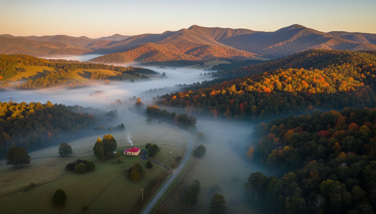
The Patch is a hidden gem, rich with diverse topography. From dense eucalyptus forests to sprawling rural properties, every corner holds a visual story waiting to be told. Traditional photography, while beautiful, can only scratch the surface. Drone photography, however, transcends ground-level limitations, revealing the intricate patterns of the landscape, the majestic scale of the Dandenongs, and the unique character of properties from a bird’s-eye perspective. Imagine showcasing your property with an encompassing view of its gardens, its proximity to the natural surrounds, and the stunning backdrop of the Ranges. This elevated viewpoint doesn’t just offer a different angle; it provides a comprehensive understanding and appreciation of your subject.
The changing seasons in The Patch are particularly spectacular from above. The vibrant greens of spring, the sun-drenched hues of summer, the fiery reds and oranges of autumn, and the misty ethereal scenes of winter are all amplified when viewed from the sky. We understand the local microclimates and the best times to capture these fleeting moments, ensuring every shot reflects the authentic, captivating beauty of our local environment. For more about the region’s natural splendour, visit the Parks Victoria – Dandenong Ranges National Park website.
Elevating Your Vision: Applications of Aerial Photography
The applications for professional aerial photography in The Patch are as vast as the landscape itself. Whether you’re a homeowner, a business, or simply someone who cherishes the beauty of Victoria, drone imagery offers a unique edge:
- Real Estate: For properties in The Patch, a comprehensive real estate drone photography package can significantly enhance listings. Show potential buyers the entire scope of a property, its land, and its majestic setting within the Dandenongs. It’s about selling a lifestyle, not just a house.
- Landscape Art: Elevate your appreciation for the local scenery. Our drone photography captures the artistic essence of The Patch, turning natural formations and vistas into stunning visual artworks perfect for home or office. Explore more of our landscape photography options.
- Commercial Projects & Developments: For local businesses or developers planning projects, drone photography offers invaluable progress monitoring, site surveys, and promotional content. Showcase your project’s integration with the natural environment.
- Events: Add an epic dimension to your special events, from weddings nestled amongst the hills to community gatherings. Aerial shots provide a grand, sweeping overview that ground-level cameras simply can’t achieve.
Our commitment to safety, expertise in flight operations, and deep understanding of local airspace regulations ensures a professional and seamless experience from start to finish. We capture stunning visuals ethically and responsibly, respecting privacy and the environment.
Choosing Your Drone Photography Partner in The Patch
When selecting a drone photography service in The Patch, local knowledge is paramount. At Image by SD, we’re not just photographers; we’re part of the community. We know the best vantage points, the optimal light conditions, and the unique characteristics of the Dandenong Ranges that make this area so special. Our professional pilots are fully licensed and insured, adhering to all Australian Civil Aviation Safety Authority (CASA) regulations, guaranteeing not only breathtaking results but also peace of mind.
We pride ourselves on a collaborative approach, working closely with our clients to understand their vision and deliver photographs that exceed expectations. From initial consultation to final delivery, our focus is on capturing the essence of your subject with creativity and technical precision. Discover the vibrant culture and natural beauty of the wider region at Visit Yarra Valley & Dandenong Ranges.
Experience The Patch’s Dandenongs Vistas From Above
Ready to see The Patch from a whole new perspective? Whether for real estate, personal projects, or commercial endeavours, Image by SD is your trusted partner for premium drone photography. Let us help you unveil the grandeur of your property or project against the magnificent backdrop of the Dandenong Ranges. Contact us today to discuss how we can bring your aerial vision to life.