Woodend, a jewel in the heart of Victoria’s stunning Macedon Ranges, offers a picturesque tapestry of rolling hills, historic charm, and vibrant natural beauty. While its quaint streets and friendly community are delightful from ground level, to truly appreciate its grandeur, one must ascend. This is where Woodend Victoria drone photography scenic views come into their own, transforming familiar landscapes into breathtaking aerial masterpieces.
Elevating Perspective: Why Woodend Demands Drone Photography
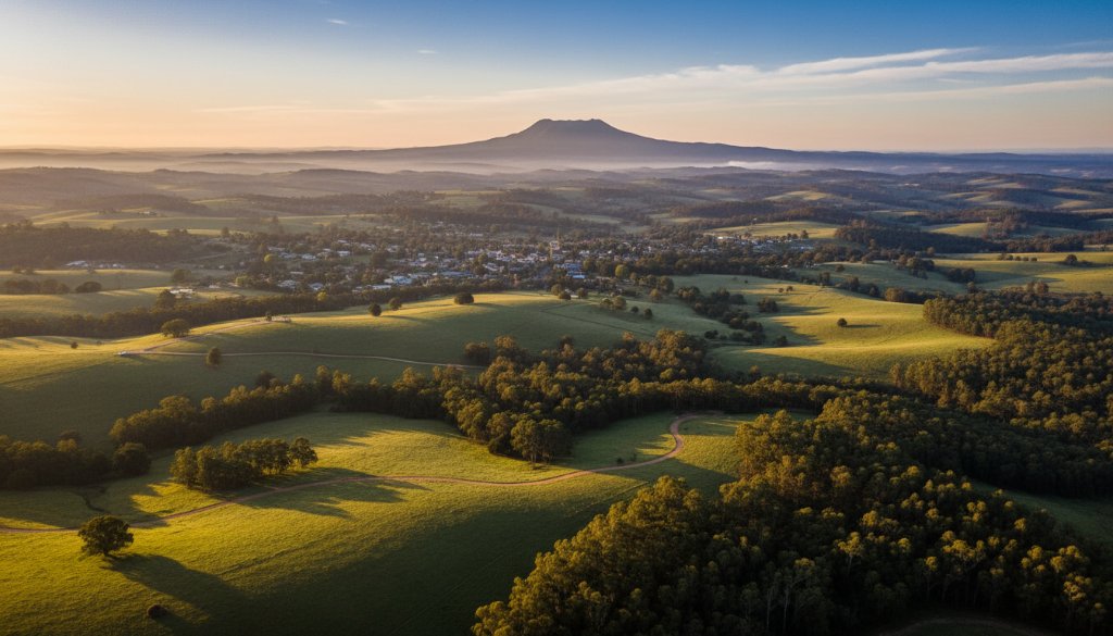
There’s a unique magic to seeing a place from above. Woodend, nestled at the foot of Mount Macedon and bordering the ancient Wombat State Forest, presents an unparalleled canvas for drone photography. Imagine sweeping vistas of vineyards bathed in golden hour light, the intricate patterns of agricultural land, or the serene flow of local waterways like the Five Mile Creek, all captured with stunning clarity and perspective that traditional photography simply cannot match.
For Visit Macedon Ranges – Woodend, showcasing the region’s natural attractions, events, and unique lifestyle often benefits immensely from a bird’s-eye view. Drone photography provides the perfect tool to highlight the expansive beauty that makes Woodend such a sought-after destination, whether for tourism, events, or a tranquil country lifestyle.
Capturing Woodend’s Essence from Above with Professional Aerial Imagery
Professional drone photography in Woodend isn’t just about taking pretty pictures; it’s about storytelling from a new vantage point. We’re able to capture the architectural elegance of historic properties, the scale of expansive landholdings, or the dynamic energy of community events like the Woodend Art Group exhibitions or local markets. The dramatic interplay of light and shadow across the landscape, particularly during sunrise or sunset over the Macedon Ranges, is simply spectacular when viewed from the air.
Consider the benefits for various applications:
- Real Estate: Showcase an entire property, its surrounding environment, and proximity to local amenities. An aerial view can truly elevate a listing, offering a comprehensive understanding that ground-level shots cannot. This is particularly effective for larger properties or those with significant landscape features. Learn more about our real estate photography services.
- Events: Capture the full scope and atmosphere of outdoor festivals, weddings, or sporting events, providing a dynamic overview of the crowd and venue. For example, a local event photography might include an aerial shot of a bustling market day.
- Commercial & Tourism: Create compelling promotional material for local businesses, wineries, or tourism operators, highlighting their unique setting and offerings. The Macedon Ranges Shire Council often needs high-quality imagery for regional promotion, and drone photography delivers just that.
- Environmental & Landscape Documentation: Ideal for documenting the changing seasons, land surveys, or showcasing the natural beauty of the area for conservation efforts. The unique flora and fauna of the Wombat State Forest, for instance, are beautifully rendered from a drone’s perspective.
At Image by SD, our certified and experienced drone pilots understand the nuances of Woodend’s terrain and weather patterns, ensuring not only stunning results but also safe and compliant operations. We pride ourselves on producing high-resolution imagery and video that truly reflect the character and charm of this beautiful region.
If you’re seeking to unlock the full visual potential of Woodend, whether for a personal project, a business venture, or to simply immortalise a special moment, consider the unmatched capabilities of professional drone photography. Let us help you unveil the spectacular, often unseen, vistas of this cherished Victorian locale. Connect with Image by SD today to discuss how we can bring your vision to life from an entirely new perspective.
For more information about Woodend and its community initiatives, you can visit the Macedon Ranges Shire Council website.